

Collection
ContributeA collection of objects related to the surveying of South Australia and to the surveyors who worked here during the 19th century. Many of these objects form a sub-collection of the Historical Relics collection.
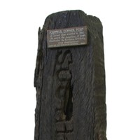
A number of the objects relate to South Australia’s first Surveyor General, Colonel William Light. These include surveyors’ chains and the first plan of Adelaide, drawn up to Light’s instructions. Another highlight of the collection is ‘Poeppel’s post’, the original marker used in 1880 by Augustus Poeppel to mark the intersection of the boundaries of South Australia, the Northern Territory and Queensland.
Significance
The history of Adelaide as a ‘planned city’ and the broader history of South Australia’s British settlement under the Wakefield system make surveying of particular importance to South Australia’s history. This collection preserves some of the tools used by early surveyors and records the development of official boundaries, as well as the understanding of and changes to territory administered by the South Australian colonial government. This collection complements other History SA collections, in particular a large collection of surveying instruments held at the South Australian Maritime Museum.
Media
Add mediaColonel William Light
Images

Hand compass and sundial, History SA collection, HT 97.531
Surveying equipment
Images

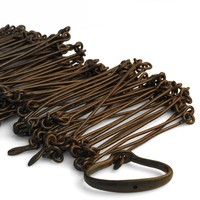
Survey chain, Migration Museum collection, HT 2003.95
Comments
CommentAdd new comment
Thanks Bruce,
That's a generous offer. I'll put you in touch with our acquisitions committee.
Good Afternoon
I am a descendant of the explorer Stephen King I have in my possession his small bible (named) that accompanied him on his expeditions. I was in your museum some 15 years ago and saw a lot of his sketches from the McDowall-Stuart expeditions. I feel that the bible should be in your museum rather than sitting here in NZ and not really being valued by future generations here. If you are interested, contact me by email. Sincerely, Bruce Roe Story